

Cooler Temps Assist Airport Fire Fight in Riverside, Orange Counties
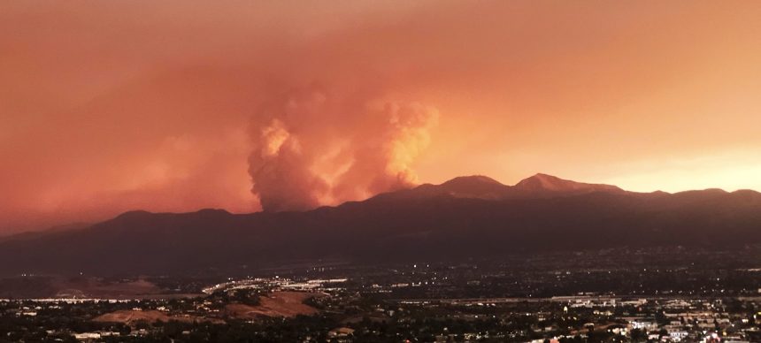
LAKE ELSINORE (CNS) – Falling temperatures continue to provide a valuable boost to firefighters battling the Airport Fire burning in Orange and Riverside counties Friday, with crews finally beginning to establish containment lines while again slowing the spread of the blaze.
As of Friday morning, the fire was estimated at 23,494 acres, with 5% containment.
Orange County Fire Authority Capt. Steve Concialdi said about 770 firefighters were battling the blaze “and more are coming to assist.”
“This marine layer and cooler temperatures along with the higher relative humidity are helping firefighters grow our containment fires and extinguish hot spots,” Concialdi said Thursday morning. “Unfortunately, due to the marine layer helicopters were unable to fly last night, but starting this morning our firefighters are improving those containment lines and going into those burn areas and extinguishing hot spots.”
“We are constructing a large dozer containment line from below the fire, starting in Robinson Ranch and behind the communities of Dover Canyon and Coto de Caza all the way to Ortega Highway just in case we have any wind shift or if the Santa Ana winds develop at some point,” Concialdi said. “This will be a barrier and will slow the fire and keep the fire away from those communities.”
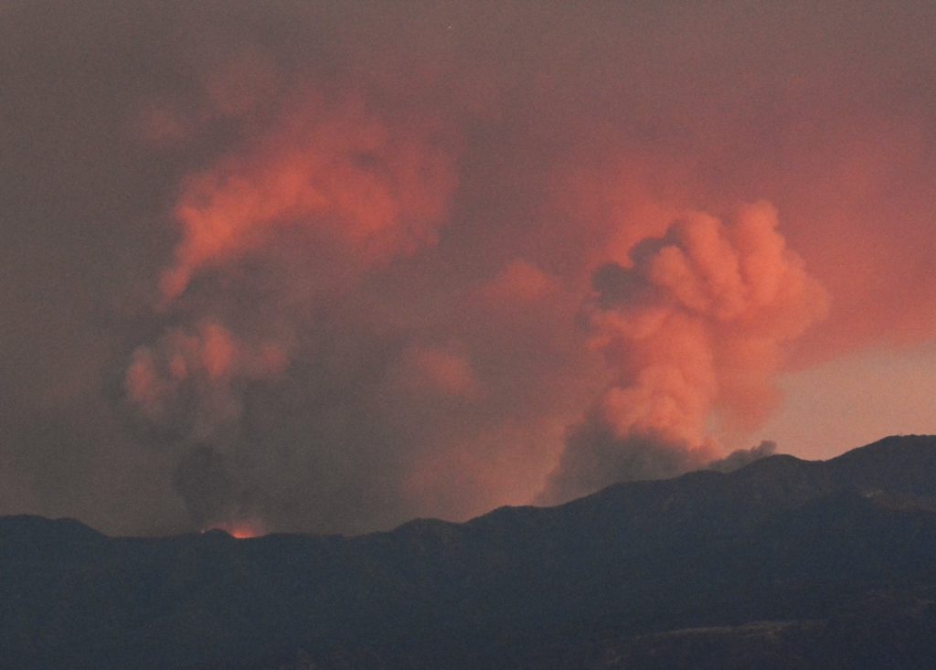
Firefighters were reinforcing containment lines southwest of the fire. A flare-up occurred in an unburned pocket north of Trabuco Canyon, but it remained within the fire’s existing perimeter. Crews were conducting reconnaissance along the Santiago Peak fire lines, and heavy equipment operators were constructing a dozer line toward the Ortega highway.
Aircraft such as Air Tankers and helicopters were utilized throughout the afternoon.
At a Wednesday afternoon news conference, OCFA Division Chief Kevin Fetterman reported two civilian injuries — one who suffered a medical emergency and one with unspecified burns — and a total of 10 firefighter injuries.
Concialdi said earlier Wednesday most of those firefighter injuries were heat-related, “but one did get stung by numerous bees, and one sustained minor burns and the other couple had some injuries from fighting the fire, but all were released from the hospital and are doing well.”
The end of the Southland’s prolonged heat wave began assisting in the firefight Tuesday night, Concialdi said. Burn scars from the Holy Fire in 2018 and 2022 also provided much-needed breaks in the fuel feeding the blaze.
Officials were reporting two structures destroyed and six more damaged.
“We can confirm that there were some homes damaged and destroyed in the communities around Ortega Highway,” but details were still being collected, Concialdi said.
As of Wednesday, the Orange County Fair and Event Center had taken in 93 horses evacuated due to the fire.
On Tuesday, the Orange County Board of Supervisors approved an emergency declaration in response to the fire, in hopes of obtaining additional financial resources for the firefight and eventual recovery. Meanwhile, Gov. Gavin Newsom secured assistance from the Federal Emergency Management Agency for all the fires in the state, including the Airport Fire, the Bridge Fire burning in Los Angeles and San Bernardino counties and the Line Fire in San Bernardino County.
The Airport Fire began about 1 p.m. Monday near Trabuco Canyon Road in the area of the remote-controlled airplane airport, said Orange County Fire Authority Capt. Sean Doran. By Tuesday morning, the fire had raced up the canyons and hillsides and crested into Riverside County, burning toward the El Cariso and Lake Elsinore areas, where evacuation warnings and orders were in place.
Evacuation warnings were issued for a host of Riverside County areas near the fire zone, generally in an area east of the Orange County line, north of the San Diego County line, south of Bedford Motor Way and west of Interstate 15.
Early Tuesday afternoon, some of those warnings became evacuation orders, impacting an area generally north of the San Diego County line, east of the Orange County line, south of Lake Elsinore near the base of Ortega Highway and west of South Main Divide Road/Grand Avenue.
On Thursday afternoon, with conditions easing, mandatory evacuations were reduced to evacuation warnings in some neighborhoods:
— an area roughly south of Temescal Canyon, west of Lake Street, east of Gateway Drive/Coyote Mesa Drive/Lincoln Street, and north of McVicker Canyon/Park Road and Patrick Court; and
— an area roughly south of Magnolia Avenue, west of Grand, east of South Main Divide Road and north of the San Diego County line.
Evacuation warnings were lifted entirely for an area generally south of Via Vista Grande, west of Clinton Keith, east of Calle Bandido/Avenida La Cresta/Via Majorca, and north of the San Diego County line.
Residents can visit https://go.genasys.com/11hh53 to determine if their homes are impacted by evacuation orders or warnings.
In Orange County, evacuation orders were in place in the areas of Ortega Highway, Caspers Park, Blue Jay Campground and El Cariso.
Evacuation warnings were issued for Robinson Ranch, Rose Canyon, Trabuco Canyon, Dove Canyon, Silverado Canyon, Modjeska Canyon and East Side Coto de Caza.
Ortega Highway was closed east of Quarry to Grand Avenue in Lake Elsinore. That area had been under a voluntary evacuation warning, but late Tuesday morning, mandatory evacuation orders were issued for areas along the highway near Caspers Park.
There were other roads were closed near the fire:
— Plano Trabuco / Joshua Drive
— Santa Margarita Parkway / Antonio Parkway
— Plano Trabuco / Robinson Ranch
— Avenida Empressa / Santa Margarita Parkway
— Antonio Parkway / Alas de Paz
— Trabuco Canyon / Trabuco Creek
— Santiago Canyon Road
— Live Oak Canyon Road
Evacuation centers were established at Temescal Canyon High School: 28755 El Toro Road in Lake Elsinore, and at Santiago High School, 1395 E. Foothill Parkway in Corona.
Animals were being sheltered at Jurupa Valley Animal Shelter, 6851 Van Buren Blvd., and at a large animal shelter at Murrieta Equestrian Center, 42670 Juniper St. Riverside County residents needing assistance with large animal evacuations can call 951-358-7387.
Fire crews on Wednesday deployed additional resources into the El Cariso area in Riverside County southwest of Lake Elsinore in hopes of shoring up structure protection and hoping to make a stand against the fire’s advance.
Talbot Hayes of the Cleveland National Forest said the fire was being driven by weather, fuel and topography. Firefighters were working in areas with grass as high as 4 feet with chaparral as high as 8 feet, Hayes said. The terrain is at times “barely hikeable even for our most fit firefighters.”
There were 36 cabins in Trabuco and Silverado canyons that firefighters had yet to assess for damage, he said.
Orange County Fire Authority Deputy Chief TJ McGovern told reporters Monday night that the fire was accidentally sparked by a county work crew. McGovern said Orange County Public Works crews were working in the area near Trabuco Creek Road, using heavy equipment to place boulders meant to replace barriers used to restrict access to the vegetation.
The OCFA was using new firefighting helicopters that can dump 1,000 gallons of water on the flames, Doran said.
The Corona-Norco Unified School District opted to close Wilson, Temescal Valley and Todd elementary schools due to the proximity of the fire and the resulting poor air quality, and all three will remain closed for the rest of the week, according to the district. Schools in the Lake Elsinore Unified School District were also closed.
The Airport Fire was one of three large wildfires burning in Southern California this week. The Line Fire had burned 37,207 acres in San Bernardino County by Thursday evening and was 21% contained, while the Bridge Fire in Los Angeles and San Bernardino counties had burned 51,792 acres and was at 0% containment.
The South Coast Air Quality Management District extended an air quality advisory until at least 11 p.m. Friday for Los Angeles, Orange and Riverside counties due to smoke from all three wildfires.
For More Fire Season News Visit www.zapinin.com/fire-season