

RIVERSIDE (CNS) – A powerful winter storm was making its way toward Riverside County Wednesday, with low-elevation snow, widespread rain showers and cold temperatures expected to impact the area beginning Thursday and into the weekend.
Scattered showers fell across parts of the region Wednesday, with that rain expected to become more widespread by Thursday morning.
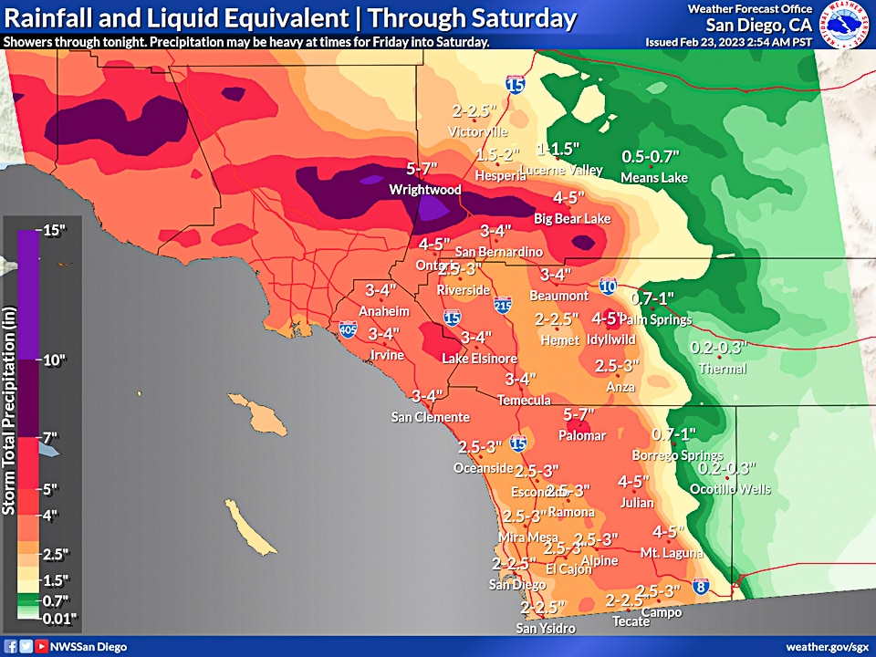
“The cold nature of this system is expected to bring snow to elevations as low as 2,000 feet,” according to the National Weather Service. “Up to 2 inches of snow may accumulate in portions of the Inland Empire and eastern San Diego County. Snow is expected to accumulate in portions of the High Desert as well. Snow is expected there by Thursday afternoon, with up to 4 inches expected. Snow levels will rise to 3,000 to 3,500 feet through the day Thursday, with snow levels closer to 4,000 feet expected by Friday morning.”
Another round of wet weather will slide into the area Friday and Saturday, bringing more widespread and heavier precipitation, forecasters said. The precipitation will be accompanied by strong south winds Friday and Friday night.
Forecasters also warned of heavy snow and gusting winds that will “create dangerous conditions in the mountains.”
“Snowfall is expected on all of the mountain ranges with the highest accumulations expected in the San Bernardino and portions of the Riverside County mountains,” according to the NWS. “Top forecast snowfall totals of 4 to up to 7 feet are expected in the mountains. For the San Bernardino and Riverside County mountains for Friday into Saturday, the combination of very heavy snow, low visibilities from snow, blowing snow, and fog, and strong gusty south winds will create blizzard conditions at times.”
A winter storm warning will be in effect until 3 p.m. Saturday in the Riverside County mountains, with forecasters anticipating 1 to 3 feet above 6,000 feet and 3 to 4 feet of snow on higher peaks. At least 4 inches of snow are anticipated in most other mountain areas, forecasters said.
A flood watch will be in effect from Friday afternoon through Saturday evening in the Riverside County valleys and mountains, along with the San Gorgonio Pass near Banning. Forecasters warned of possibly excessive runoff that could result in flooded rivers, creeks, streams and other low-lying areas.
According to the NWS, rain could fall at a rate of a half-inch to 0.6 inches per hour, with the highest rates expected on the southwest facing mountain slopes.
Daytime temperatures in Riverside County valleys are expected in the 40s and 50s, but dipping into the 30s at night. Mountain areas could see temperatures in the low 20s at night, possibly falling into the teens on Friday and Saturday nights.
Very interesting points you have remarked, thank you for posting.Blog monry
Your article helped me a lot, is there any more related content? Thanks! https://www.binance.com/ru/register?ref=V3MG69RO
Thanks for sharing. I read many of your blog posts, cool, your blog is very good. https://accounts.binance.com/register?ref=P9L9FQKY
Thank you for your sharing. I am worried that I lack creative ideas. It is your article that makes me full of hope. Thank you. But, I have a question, can you help me?
I’m extremely impressed together with your writing talents and also with the structure to your weblog. Is that this a paid subject matter or did you modify it yourself? Anyway keep up the nice high quality writing, it is uncommon to look a nice blog like this one nowadays!
Can you be more specific about the content of your article? After reading it, I still have some doubts. Hope you can help me.
I don’t think the title of your article matches the content lol. Just kidding, mainly because I had some doubts after reading the article.