

RivCo Cleanup Underway Following Deluge from Tropical Storm Hilary – 11:14 A.M.
RIVERSIDE (CNS) – Tropical Storm Hilary moved out of Riverside County
today, but the heavy rain Sunday and overnight caused severe flooding in parts
of the Coachella Valley, leaving some residents with no way in or out of their
city.
As of Monday morning, Interstate 10 eastbound was closed from Haugen-
Lehman Way to slightly past Monterey Avenue. The closure was due to mudslides
in the eastern Coachella Valley, according to California Highway Patrol public
information officer Jason Montez. He said eastbound traffic was being turned
around, and it was unknown how long the closure might last.
Officials with the city of Desert Hot Springs reported Monday morning
that there was no way in or out of the city due to all the road closures
throughout the Coachella Valley.
The Palm Springs, Coachella Valley and Desert Sands unified school
districts all canceled classes Monday. Only essential staff will report to work
and assess damage and perform necessary repairs, CVUSD officials said. Desert
Mirage High School, 86150 66th Ave. in Thermal, was operating as a temporary
shelter for families displaced from their homes by the storm.
The city of Palm Springs issued a local emergency declaration Sunday
afternoon as downpours from the storm inundated roadways and led to wide-scale
road closures. The city of Indio followed suit late Sunday night, saying the
storm has “threatened local infrastructure and public health and safety.”
Cathedral City also issued a local emergency declaration.
The California National Guard reported Monday morning that its 330th
Military Police Company responded to Cathedral City and Palm Springs to aid the
fire departments during rescue operations.
Nearby Palm Desert also reported an array of road closures due to
flooding. Video from other cities in the area showed cars swamped with
floodwater, but there were no immediate reports of injuries associated with the
storm.
Hilary brought rain to the county well ahead of the storm even making
landfall in Southern California. But once it did reach land Sunday afternoon,
the rain intensified and storm conditions worsened. National Weather Service
forecasters warned residents that potentially dangerous flooding was likely,
and there was even a slight chance of tornadoes developing in the area.
“Hilary is now post-tropical with the remnant moisture spreading
north of the area,” the NWS reported Monday morning. “Showers will diminish
this morning with a chance of showers and thunderstorms for the mountains and
deserts for this afternoon.”
A flood watch will be in effect until late Monday night for Riverside
County mountains, the Coachella Valley and the San Gorgonio Pass near Banning.
The watch will expire at 10:15 a.m. Monday in Riverside County valleys.
All College of the Desert sites in Palm Desert were be closed Monday
due to the storm. The college announced on social media that “Tropical Storm
Hilary has flooded the area, including some campus facilities.”
No business will be conducted at any of the locations except for
maintenance and campus safety, officials said.
In the Coachella Valley, several cities, including Palm Springs, which
recorded 3 inches of rain Sunday, reported that 911 services were down, but
PSPD reported Monday morning that calls were being routed to its call center.
Most of Riverside County received between 1.5 and 4 inches of rain
over the 48-hour storm period, with some notable exceptions. Mount San Jacinto
reported 11.74 inches, according to the NWS. More than 3.8 inches fell in Palm
Desert, 3.23 inches at Palm Springs International Airport and 5.75 inches in
Morongo Valley.
Gov. Gavin Newsom issued a State of Emergency for much of Southern
California to support the Hilary response and recovery efforts as the state
continues mobilizing and coordinating resources ahead of the storm’s forecasted
impacts.
The governor signed an emergency proclamation Saturday in San Diego
while visiting with California National Guard troops. He met with first
responders and local officials, including San Diego Mayor Todd Gloria. He was
also in touch with federal officials, including the White House.
On Sunday morning, the Federal Emergency Management Agency pre-
positioned supplies at March Air Reserve Base in Riverside, and a FEMA Incident
Management Assistance Team deployed to the California Office of Emergency
Services and was prepared to assist with any requests for federal assistance.
Additional teams were on standby for deployment if necessary, officials said.
Care and reception centers were available at Desert Mirage High School
at 86150 66th Ave. in Thermal and at the Banning Community Services Center
at 789 N. San Gorgonio Ave., both open 24 hours.
Residents requiring help with their animals were encouraged to call
the Riverside County Department of Animal Services at 951-358-7387.
Before Sunday, a tropical storm had not landed in Southern California
since 1939.
Monday – 8:34 A.M.

Hurricane Hilary Live Updates – Hilary Floods Portions of Riverside County; Residents Asked to Stay Indoors
RIVERSIDE (CNS) – Tropical Storm Hilary packed a wallop in Riverside County today, dumping heavy rain over a vast area and causing severe flooding in parts of the Coachella Valley.
The city of Palm Springs issued a local emergency declaration Sunday afternoon as downpours from the storm inundated roadways and led to wide-scale closures of roads. Nearby Palm Desert also reported an array of road closures due to flooding. A stretch of Interstate 10 was closed in both directions in the area Sunday evening due to floodwater.
Video from other cities in the area showed cars swamped with floodwater.
There were no immediate reports of injuries associated with the storm.
Hilary brought rain to the county well ahead of the storm even making landfall in Southern California. But once it did reach land, the rain intensified and storm conditions worsened. National Weather Service forecasters warned residents that potentially dangerous flooding was likely, and there was even a slight chance of tornadoes developing in the area.
Hilary weakened from a Category 1 hurricane to a tropical storm early Sunday, and it made landfall near San Diego late Sunday afternoon. The NWS warned of “potentially historic amounts of rainfall” that was “expected to cause life-threatening to locally catastrophic flash, urban and arroyo flooding including landslides, mudslides, and debris flows through early Monday morning.”
A flood watch will be in effect until 5 a.m. Monday for much of Riverside County, and residents were advised to remain sheltered. A more serious flash flood warning was issued for most of Riverside and San Bernardino counties earlier in the day, but it was allowed to expire at 8:30 p.m.
An evacuation order was issued on Sunday around 9 a.m. for the Mias zone in the Apple/El Dorado burn scar, north of Banning and near the Morongo Reservation, according to the Riverside County Emergency Management Department.
A voluntary evacuation warning was issued for Highland Springs, Beaumont, Hemet, Banning and Reche Canyon Road in Colton ahead of the storm, according to the EMD.
A tropical storm warning remained in effect Sunday evening across Southern California, including most of Riverside County. The storm was slowly moving through the north and was expected to be clear of the area by Monday morning, although showers could continue through the day, forecasters said.
All College of the Desert sites in Palm Desert will be closed Monday due to the storm. The college announced on social media that “Tropical Storm Hilary has flooded the area, including some campus facilities.”
No business will be conducted at any of the locations except for maintenance and campus safety, officials said.
Gov. Gavin Newsom issued a State of Emergency for much of Southern California to support the Hilary response and recovery efforts as the state continues mobilizing and coordinating resources ahead of the storm’s forecasted impacts.
The governor signed an emergency proclamation Saturday in San Diego while visiting with California National Guard troops. He met with first responders and local officials, including San Diego Mayor Todd Gloria. He was also in touch with federal officials, including the White House.
On Sunday morning, the Federal Emergency Management Agency pre- positioned supplies at March Air Reserve Base in Riverside, and a FEMA Incident Management Assistance Team deployed to the California Office of Emergency Services and was prepared to assist with any requests for federal assistance. Additional teams were on standby for deployment if necessary, officials said.
Care and reception centers were available at Desert Mirage High School at 86150 66th Ave. in Thermal and at the Banning Community Services Center at 789 N. San Gorgonio Ave. in Banning, both open 24 hours.
Residents requiring help with their animals were encouraged to call the Riverside County Department of Animal Services at 951-358-7387.
A tropical storm has not landed in Southern California since 1939.
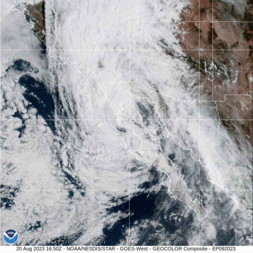
To monitor the hurricane’s satellite path, visit https://www.star.nesdis.noaa.gov/goes/floater.php?stormid=EP092023.
Radar – 8:30 P.M.
Hilary Flood Warning – 8:15 p.m.
BULLETIN
Flash Flood Warning
National Weather Service San Diego CA
815 PM PDT Sun Aug 20 2023
The National Weather Service in San Diego has extended the
* Flash Flood Warning for…
Riverside County in southern California…
* Until 1130 PM PDT.
* At 815 PM PDT, Doppler radar and automated rain gauges indicated
heavy rain continuing to fall across the warned area. Flash
flooding is ongoing or expected to begin shortly.
HAZARD…Life threatening flash flooding. Heavy rain producing
flash flooding.
SOURCE…Radar and automated gauges.
IMPACT…Life threatening flash flooding of creeks and streams,
urban areas, highways, streets and underpasses.
* Some locations that will experience flash flooding include…
Indio, northeastern Palm Springs, Coachella, Mt San Jacinto State
Park, Cathedral City, Palm Desert, eastern Desert Hot Springs,
Rancho Mirage, North Palm Springs and Hwy 74 Between Anza And Palm
Desert.
PRECAUTIONARY/PREPAREDNESS ACTIONS…
Turn around, don t drown when encountering flooded roads. Most flood
deaths occur in vehicles.
Be aware of your surroundings and do not drive on flooded roads.
Radar – 6:00 P.M.
Palm Springs Declares Local Emergency – 3:37 P.M.
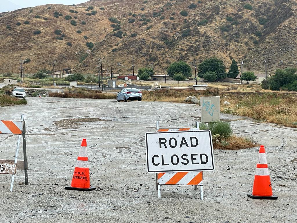
Palm Springs City Manager Scott Stiles has declared a local emergency due to “critically dangerous impacts” of the tropical storm. Police and fire officials are continuing to urge people to remain home. According to the city, current road closures due to flooding are in place at Dinah Shore at the bridge from Palm Springs to Cathedral City, Farrell Drive between Mesquite Drive and Ramon Road, El Cielo at Mesquite Drive, Araby at the wash and Golf Club Drive at the wash. North Indian Canyon Drive, Gene Autry Trail and Vista Chino Drive are all closed at the wash.
Box Canyon Rd. to Mecca Closed – 3:42 P.M.
Box Canyon Road from Interstate 10 to the All American Canal in
the Mecca area is closed due to flooding, the Riverside County Transportation
Department is reporting.
Quake Updated to 5.1, Felt in Riverside County – 3:46 P.M.
The temblor, initially given a magnitude of 5.0 but later upgraded to 5.1, struck at 2:41 p.m. about 4 miles southeast of Ojai, according to the U.S. Geological Survey. It was quickly followed by a series of aftershocks, the largest of them measuring a magnitude of 3.8.
There were no immediate reports of injuries or damage attributed to the quake, but it was widely felt across the region, with shaking felt across Los Angeles County’s South Bay and into Riverside County.
Ventura County Quake, 5.0 Preliminary Reading and Aftershocks Rattle Southland in Midst of Storm – 3:14 P.M.
RIVERSIDE – On a day the region was already coping with a major tropical storm, a powerful earthquake centered in Ventura County shook most of Southern California Sunday.
The temblor, with a magnitude of 5.0, struck at 2:41 p.m. in Ojai, according to the U.S. Geological Survey. It was quickly followed by a series of aftershocks, the largest of them measuring a magnitude of 3.6.
There were no immediate reports of injuries or damage attributed to the quake, but it was widely felt across the region, with shaking felt across Los Angeles County’s South Bay and into Riverside County.
Earthquake expert Lucy Jones wrote on X, formerly Twitter, that the shaker appeared to have been preceded to a series of foreshocks that began Saturday morning.
The quake occurred on a day the remnants of Hurricane Hilary, which weakened into a tropical storm before it made landfall, was bringing heavy rain across Southern California and had first responders already on high alert.
The National Weather Service said there was not expected to be any threat of a tsunami due to the quake.
2:42 P.M.
Winds picking up in Riverside County from the front wall of Tropical Storm Hilary. Eye of the storm is still south of Tijuana
Electrical Poles Go Down in Thermal, Knocking Out Power – Update 2:10 P.M.
THERMAL (CNS) – As many as 2,000 people were without power for an “unknown duration” in Thermal Saturday after 50 electrical poles went down, authorities said.
The electrical hazard was reported at 7:36 p.m. Friday at Harrison Street between Avenue 58 and Avenue 63, according to Cal Fire Riverside.
Utility workers with the Imperial Irrigation District were on the scene to de-energize the power poles.
The Riverside County Emergency Management Department had a shelter open Saturday for residents without power. It is located at Desert Mirage High School, 86150 66th Ave. in Thermal.
Some roads were closed in Harrison Street, fire officials said.
The cause of the hazard was not known, and there were no reports of any injuries or any structure damage.
Mias Canyon Rd. Closure – Update: 12:31 P.M.
Riv. Co. Sheriffs have closed Mias Canyon Rd. at Bluff St. north of Banning because it’s very dangerous beyond here in heavy rains. Earlier this year, residents beyond this river-crossing point became trapped for several days until the rains and flooding had subsided and they could safely cross this point. Sheriff’s deputies said there’s no mandatory evacuation right now, but the encourage residents to evacuate voluntarily because recent wild fires have increased the chances of flash flooding.
Via Don Ray
UPDATE: 12:31 P.M.
An evacuation order was issued on Sunday around 9 a.m. for the Mias zone in the Apple/El Dorado burn scar, north of Banning and near the Morongo Reservation, according to the Riverside County Emergency Management Department.
A voluntary evacuation warning was issued for Highland Springs, Beaumont, Hemet and Banning ahead of the storm, according to the EMD.
The NWS Storm Prediction Center reported that a couple tornadoes are possible Sunday afternoon in the southeastern areas of California such as Palm Springs and Blythe.
Hurricane Hilary Heads Toward Riverside County; Residents Asked to Stay Indoors – Sunday at 11:31 A.M.
To monitor the hurricane’s satellite path, visit https://www.star.nesdis.noaa.gov/goes/floater.php?stormid=EP092023.
RIVERSIDE (CNS) – Riverside County was under an unprecedented tropical storm warning Sunday, as Hilary moved toward Southern California off the Baja California coast and forecasters warned of the potential for dangerous flooding in the Inland Empire.
Hilary weakened from a Category 1 hurricane to a tropical storm early Sunday, the National Weather Service announced, but it was still expected to cause potentially life-threatening flooding in the mountain and desert areas.
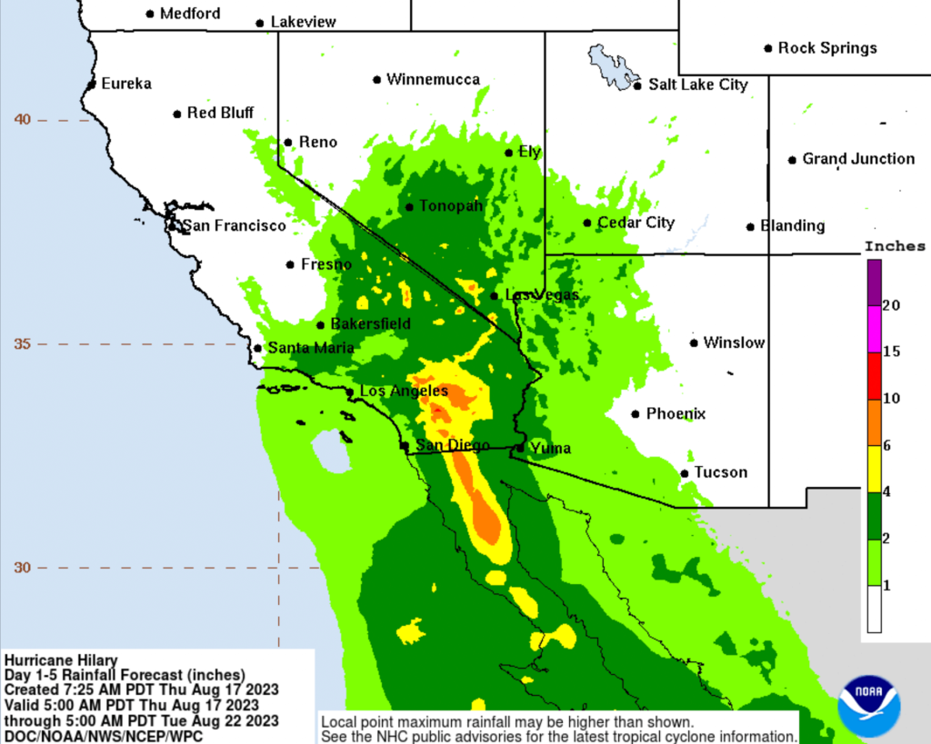
The storm was expected to make landfall near San Diego early Sunday afternoon. The NWS warned of “potentially historic amounts of rainfall” that was “expected to cause life-threatening to locally catastrophic flash, urban and arroyo flooding including landslides, mudslides, and debris flows through early Monday morning.”
A flood watch was in effect until 5 p.m. Monday for much of Riverside County, and residents were advised to remain sheltered this weekend. Winds of 30-40 mph were expected Sunday, with gusts up to 55 mph, according to the NWS.
An evacuation order was issued on Sunday around 9 a.m. for the Mias zone in the Apple/El Dorado burn scar, north of Banning and near the Morongo Reservation, according to the Riverside County Emergency Management Department.
As of 9 a.m. Sunday, temporary closures were in effect at the washes of Indian Canyon, Gene Autry and Vista Chino due to the impending storm, according to Palm Springs police.
Excessive runoff may result in flooding of rivers, creeks, streams and other low-lying and flood-prone locations. Low-water crossings could be flooded.
“Unnecessary travel is discouraged on Sunday due to the high flooding potential,” forecasters said. “Emergency plans should include the potential for extreme flooding from heavy rain. Evacuations and rescues are likely.”
The NWS warned residents to secure porches, carports and unanchored mobile homes in coastal and valley locations.
Some areas in the mountain and deserts could see over 2 inches of rain per hour during the peak storm period, and up to 10 inches total. Low desert areas could receive 7 inches of rain, with valleys areas getting up to 3 inches forecasters said.
Those living in areas in danger of flooding quickly were advised to prepare to evacuate.
Gov. Gavin Newsom issued a State of Emergency for much of Southern California to support the Hilary response and recovery efforts as the state continues mobilizing and coordinating resources ahead of the storm’s forecasted impacts.
The governor signed an emergency proclamation Saturday in San Diego while visiting with California National Guard troops. He met with first responders and local officials, including San Diego Mayor Todd Gloria. He was also in touch with federal officials, including the White House.
On Sunday morning, the Federal Emergency Management Agency pre- positioned supplies at March Air Reserve Base in Riverside, and a FEMA Incident Management Assistance Team deployed to the California Office of Emergency Services and was prepared to assist with any requests for federal assistance. Additional teams were on standby for deployment if necessary, officials said.
The impact of the storm was expected to peak Sunday afternoon and evening, with rain tapering off through Monday evening for most areas.
A tropical storm has not landed in Southern California since 1939.
Updated Friday
Hurricane Hilary Heading Towards Southern California – Live Link
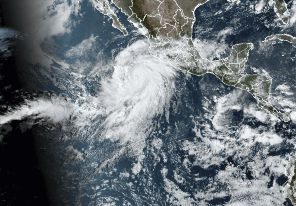
Hurricane Hilary
MEXICO CITY (Combined Sources)— Tropical Storm Hilary strengthened into a hurricane early Thursday off Mexico’s Pacific coast threatening to become a major hurricane as it keeps heading north by northwest over the ocean, toward the Baja, with a current trajectory placing Southern California directly in its path.
At print time, the U.S. National Hurricane Center said that Hilary had maximum winds of 85 mph and it was located 365 miles from Cabo Corrientes in Mexico.
According to the National Oceanic and Atmospheric Administration (NOAA), as of Noon Thursday, “Hilary has continued to intensify rapidly. The cloud pattern of this large hurricane is very impressive, with extremely intense deep convection and cloud tops…Satellite intensity estimates are wide-ranging.
It continues, “Over the next few days, a mid-level ridge to the north of Hilary is forecast to shift eastward while a mid-level low remains near the California coast. This evolution of the steering currents should result in a gradual turn toward the north in a couple of days, which would bring Hilary near the Baja California peninsula in 72 hours or so and near the U.S./California border in 3-4 days. The official forecast track is very similar to the previous one. Although there is fairly high confidence in the track prediction, Hilary’s oblique angle of approach to the west coast of the Baja California peninsula makes it nearly impossible to know at this point if the center will remain just offshore or move over the peninsula before reaching the southwestern United States.
“Rainfall impacts from Hilary within the Southwestern United States are expected to peak this weekend into Monday,” the National Hurricane Center wrote in a report. “Flash, urban, and arroyo flooding is possible with the potential for significant impacts.”
The area affected by heavy rainfall may include the stretch between San Diego and Yuma, Arizona. An area between Bakersfield, and Tucson could also see rain.
To monitor the hurricane’s satellite path, visit https://www.star.nesdis.noaa.gov/goes/floater.php?stormid=EP092023.
For More Local News Visit www.zapinin.com.
https://radar.weather.gov/?settings=v1_eyJhZ2VuZGEiOnsiaWQiOm51bGwsImNlbnRlciI6Wy05NS4wMSwzNi45ODVdLCJsb2NhdGlvbiI6bnVsbCwiem9vbSI6NH0sImFuaW1hdGluZyI6ZmFsc2UsImJhc2UiOiJzdGFuZGFyZCIsImFydGNjIjpmYWxzZSwiY291bnR5IjpmYWxzZSwiY3dhIjpmYWxzZSwicmZjIjpmYWxzZSwic3RhdGUiOmZhbHNlLCJtZW51Ijp0cnVlLCJzaG9ydEZ1c2VkT25seSI6ZmFsc2UsIm9wYWNpdHkiOnsiYWxlcnRzIjowLjgsImxvY2FsIjowLjYsImxvY2FsU3RhdGlvbnMiOjAuOCwibmF0aW9uYWwiOjAuNn19